|
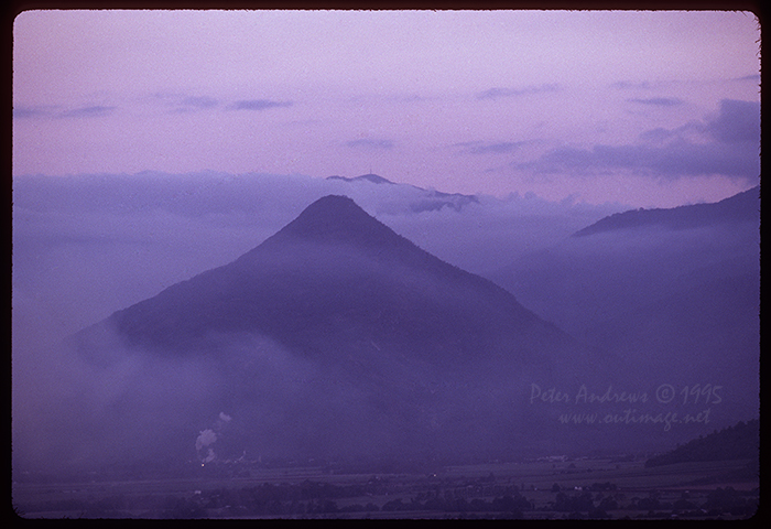 |
Evening fog after a wet day surrounds Walshes Pyramid (922 metres) above Gordonvale, south of the northern Queensland city of Cairns, Australia. The higher Mountain in the distance behind Walshes Pyramid is Mt Bellenden Ker, the second highest mountain in Queensland at 1,593 metres (5,226ft) and part of the Bellenden Ker Range; also known as the Wooroonooran Range.
The highest mountain in the state of Queensland at 1,611 metres (5,285ft) just a little further south along the Bellenden Ker Range, is Mt Bartle Frere (local indigenous name is Chooreechillum).
Much of this mountain range is contained within the Wooroonooran National Park, one of the Wet Tropics World Heritage Areas, declared as a World Heritage Site in 1988. The small clouds of steam seen at the foot of Walshes Pyramid are from the Gordonvale Sugar Mill.
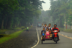
For all of my adult life I have always had this strong attraction for the tropical regions around the planet. During the southern hemisphere winter months for many years during the 1980's and 1990's, I was fortunate to mostly ride a motorcycle from the chilly southeast of Australia to the far tropical north.
These road trips often lasted from four to six weeks in duration and most overnight breaks from riding were ad hoc and basic just-off-the-road camping in a tent, sometimes with a campfire when it is safe and resources were available to have one. Some nights were also spent in a small-town pub room at times when the weather had got a bit too challenging or when the location itself was worthy of some social investment.
The last few of these long road trips were done in a cheap, but a quite decent little car that was well prepared for such long journeys. Two of these were old 1.8L four cylinder Holden Sunbirds, which were easy to fix and maintain for a minimal expense and handled both winding mountain paved roads and rough gravel with ease.
All journeys completed either by car or bike involved travelling mostly on back roads that frequently crossed the mountain ranges many times during each trip; between the east coast and the western slopes of the Great Dividing Range which runs top to bottom of the entire east coast of Australia.
Over time, experience of travelling these roads led to having an extensive and reliable list of places, highly suitable to aim for as an individual day's destination and much of this was achieved without the need of a map. Having a very strong network of friends living in various locations up and down the entire east coast in regional cities, small rural towns and other locations far from any town, was also highly valued. Travelling great distances also provided wonderful opportunities socially catch-up and strengthen the bonds of these long lasting friendships, well before the existence of social media and even the internet itself.
Most of these journeys to Australia's tropical north took me as far as the wonderful city of Townsville for many years. But it was those fewer journey's further north to places like Cairns, the Daintree, Cape Tribulation, Cooktown, the Atherton Tableland and beyond have always been really special.
The extended road journey really starts to impress, just north of Ingham when you climb up small mountain range and arrive at a lookout with views over a valley with a narrow mangrove estuarine channel, running between the mainland and the mountainous Hinchinbrook Island. Down the hill and out of the bushland into the town of Cardwell on the coast, the road heads back inland through a huge valley of sweet-smelling sugarcane, surrounded by mountains cloaked in dense rainforest. Then you arrive at Tully with it's staggering high annual rainfall, possibly as a result of its location in a valley between the start of a mountain range to the west and another smaller range of mountains in the east.
Eventually the gap between the two ranges narrows as you travel north and the aroma of rainforest pepper trees and other wonderful fragrances tantalise your senses, replacing the sweet smell of raw sugar. Then as your senses are teased with these competing aromas of pepper and sugar, what is now the Wooroonooran Range increasingly dominates the view to the west as you pass through the cane fields of the South Johnstone and onto the town of Innisfail. Not long after that, the highway you are on suddenly takes you to the base of the highest mountain in Queensland, Mt Bartle Frere.
The view as with the cacophony of competing sweet, sour and hot aromas is to say the very least is mind-blowing. The road continues, clinging onto the eastern foot of the Wooroonooran Range past Bellenden Ker and eventually, Walshes Pyramid. By now you are cruising gently down the middle of another valley into the city of Cairns, the staging point of many more greater adventures to come.
Story by Peter Andrews, Sunday June 11, 2017. Photo taken by Peter Andrews from Lake Morris Road, just west of Cairns on Tuesday July 11, 1995. |
| Outimage Publications © 1995 and 2017. |
|
|
|
| Outimage Links and Site Info |
 |
 |
|
| |
|
|
| |
|
 |
 |
| Outimage Help Page |
Copyright Info |
| |
|
|
|
|
| This page was checked and found to be a valid XHTML 1.0 Transitional webpage by the WC3 organisation. |
|
|
|
|
|
|
|
|
|
|